Store nearby Maynach Store & Party
Coronavirus disease (COVID-19) Situation
confirmed cases
1059893
deaths
8727
Panama
Store nearby Maynach Store & Party
Maynach Store & Party
Vista Alegre Panama
contacts phone
:
+507
Latitude:
8.9329213
, Longitude:
-79.6994212
read more
nearest Store
26 m
Clinica Y Farmacia San Felipe
Vista Alegre
Store
read more
285 m
Electrocom
Via Interamericana Plaza King, Vista Alegre
Store
read more
319 m
metal mecanica alevid
Vista Alegre
Store
read more
398 m
MELO VISTA ALEGRE
Vista Alegre
Store
read more
419 m
Comasa | Vista Alegre
Vista Alegre
Store
read more
468 m
Gruas Lucero
Vista Alegre
Store
read more
639 m
Materiales felipe
Vista Alegre
Store
read more
726 m
Almacen 88 No. 2
Vista Alegre
Store
read more
780 m
Hedecor
Vista Alegre
Store
read more
813 m
Almacen Y Ferreteria LG
Vista Alegre
Store
read more
911 m
Pacaro Impresores
Vista Alegre
Store
read more
968 m
Zermat Sucursal Vista Alegre
PLAZA VICTOR, FRENTE A COCHEZ, SEGUNDO PISO, Vista Alegre
Store
read more
986 m
Melo Vista Alegre 2
Vista Alegre
Store
read more
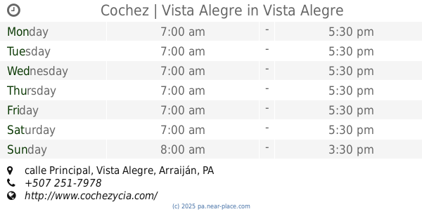
996 m
Cochez | Vista Alegre
al lado de Novey, calle Principal, Vista Alegre
Store
read more
1.253 km
INV Franco Silva s.a
cc altos de cánceres
Store
read more
1.32 km
Auto accesorios el Chinito
Vista Alegre
Store
read more
1.357 km
Chicken Factory | Westland Mall
Chicken Factory Westland, Panamá Arraiján
Store
read more
1.376 km
Create Hair Salon
Vista Alegre
Store
read more
1.416 km
GNC Live Well | Westland Mall
Vista Alegre
Store
read more
1.515 km
Ferremart | Westland Mall
Vista Alegre
Store
read more
1.536 km
Wendys Kids
Vista Alegre
Store
read more
1.657 km
Productos Promocionales
Calle 1ra., Nuevo Arraiján
Store
read more
1.696 km
Minisuper Rambo
Nuevo Arraijan
Store
read more
1.857 km
Auto Center Fashion
Nuevo Arraijan
Store
read more
2.371 km
Materiales de construccion andres
Panama
Store
read more
📑
all categories
Accounting
Administrative area level 1
Administrative area level 2
Airport
Amusement park
Aquarium
Art gallery
Atm
Bakery
Bank
Bar
Beauty salon
Bicycle store
Book store
Bowling alley
Bus station
Cafe
Campground
Car dealer
Car rental
Car repair
Car wash
Casino
Cemetery
Church
City hall
Clothing store
Colloquial area
Convenience store
Courthouse
Dentist
Department store
Doctor
Electrician
Electronics store
Embassy
Finance
Fire station
Florist
Food
Funeral home
Furniture store
Gas station
General contractor
Grocery or supermarket
Gym
Hair care
Hardware store
Health
Hindu Temple
Home goods store
Hospital
Insurance agency
Jewelry store
Laundry
Lawyer
Library
Liquor store
Local government office
Locality
Locksmith
Lodging
Meal delivery
Meal takeaway
Mosque
Movie theater
Moving company
Museum
Natural feature
Neighborhood
Night club
Painter
Park
Parking
Pet store
Pharmacy
Physiotherapist
Place of worship
Plumber
Point of interest
Police
Post office
Premise
Real estate agency
Restaurant
Roofing contractor
Route
Rv park, camping
School
Shoe store
Shopping mall
Spa
Stadium
Storage
Store
Subpremise
Subway station
Supermarket
Synagogue
Taxi stand
Train station
Transit station
Travel agency
University
Veterinary care
Zoo
administrative area level 3
sublocality level 1
↑