Bar nearby Le Cactus
Panama
Bar nearby Le Cactus
Le Cactus
Avenida Sur Santiago, Santiago, Santiago, PA Panama
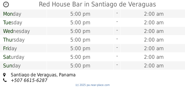
contacts phone
:
+507
Latitude:
8.0960541
, Longitude:
-80.9816425
larger map & directions
read more
nearest Bar
137 m
Lucky 7 Central
Avenida Hector Alejandro Santacoloma, Santiago
Bar
read more
407 m
Indio's Pool Bar & Lounge
Calle 9a, Santiago
Bar
read more
485 m
Bar California
Avenida A, Santiago
Bar
read more
563 m
Play Sport Bar
Santiago
Bar
read more
570 m
El Escondite De Amanda
Santiago
Bar
read more
683 m
Koppas Discoteca
koppas discoteca
Bar
read more
714 m
Route 88 BAR & LOUNGE
Ave. Hector Alejandor Santacoloma, Santiago
Bar
read more
1.041 km
La Mata
Santiago
Bar
read more
1.056 km
bar vega vega la carreta
Calle 9a, Santiago
Bar
read more
1.19 km
Tikos Bar Santiago Veraguas
calle11, Santiago
Bar
read more
1.409 km
Red House Bar
Santiago
Bar
read more
1.437 km
Bar El Descanso
Ruta 33, Santiago
Bar
read more
1.549 km
Bar El Puente
Santiago
Bar
read more
1.565 km
Terraza Bar
Carretera Panamericana, Santiago
Bar
read more
1.636 km
Bar Il Capo - Hotel Gran David
Santiago
Bar
read more
1.775 km
Bar el laurel
Interamericana, Santiago
Bar
read more
1.837 km
Bohemios Restaurante Bar
Santiago
Bar
read more
1.898 km
Broncos Bar
Avenida Eduardo Santos B., Santiago
Bar
read more
2.043 km
Bar Las Terrazaz Donde Cholo Polo
detras del antiguo flor de liz, Santiago
Bar
read more
2.659 km
Realeza
Carretera Panamericana, Santiago
Bar
read more
2.892 km
Beers House Bar & Grills
Santiago
Bar
read more
2.934 km
Bar Restaurante Éxodo
Carretera Panamericana, Santiago
Bar
read more
2.956 km
Caña Restaurante
Interamericana, Santiago
Bar
read more
3.891 km
Tao's Bar
Santiago
Bar
read more
4.588 km
Turicentro Doña Gladis
Los Algarrobos
Bar
read more
📑
all categories
Accounting
Administrative area level 1
Administrative area level 2
Airport
Amusement park
Aquarium
Art gallery
Atm
Bakery
Bank
Bar
Beauty salon
Bicycle store
Book store
Bowling alley
Bus station
Cafe
Campground
Car dealer
Car rental
Car repair
Car wash
Casino
Cemetery
Church
City hall
Clothing store
Colloquial area
Convenience store
Courthouse
Dentist
Department store
Doctor
Electrician
Electronics store
Embassy
Finance
Fire station
Florist
Food
Funeral home
Furniture store
Gas station
General contractor
Grocery or supermarket
Gym
Hair care
Hardware store
Health
Hindu Temple
Home goods store
Hospital
Insurance agency
Jewelry store
Laundry
Lawyer
Library
Liquor store
Local government office
Locality
Locksmith
Lodging
Meal delivery
Meal takeaway
Mosque
Movie theater
Moving company
Museum
Natural feature
Neighborhood
Night club
Painter
Park
Parking
Pet store
Pharmacy
Physiotherapist
Place of worship
Plumber
Point of interest
Police
Post office
Premise
Real estate agency
Restaurant
Roofing contractor
Route
Rv park, camping
School
Shoe store
Shopping mall
Spa
Stadium
Storage
Store
Subpremise
Subway station
Supermarket
Synagogue
Taxi stand
Train station
Transit station
Travel agency
University
Veterinary care
Zoo
administrative area level 3
sublocality level 1
↑