Hospital nearby Centro De Salud De Las Lomas
Panama
Hospital nearby Centro De Salud De Las Lomas
Centro De Salud De Las Lomas
Las Lomas Panamá
contacts phone
:
+507
Latitude:
8.4270147
, Longitude:
-82.3924734
read more
nearest Hospital
57 m
Centro de Salud
Las Lomas
Hospital
read more
2.961 km
Centro de Salud Ivu Dos Pinos
Barrio Bolivar, Calle B Norte, David
Hospital
read more
3.076 km
ZOONOSIS
David
Hospital
read more
3.159 km
Hospital Cattan
David
Hospital
read more
3.163 km
Clinica Cattan
David
Hospital
read more
3.344 km
clinica san francisco de asis
edificio 224, Avenida Francisco Clark, David
Hospital
read more
3.414 km
Clínica Santa Fe
David
Hospital
read more
3.546 km
Laboratorio Clinico Hemolab Sucursal 1
David
Hospital
read more
3.684 km
ULAPS Nuevo Vedado
David
Hospital
read more
3.764 km
Clinica Del Niño
Calle B Norte, David
Hospital
read more
3.764 km
Child Clinic
Calle B Norte, David
Hospital
read more
3.798 km
Policlinica Gustavo A. Ros
David
Hospital
read more
3.802 km
Policlínica Gustavo A. Ross
Calle C Norte, David
Hospital
read more
3.844 km
Centro Medico San Francisco
Calle F Norte, David
Hospital
read more
3.882 km
Clinica doctor cattan
David
Hospital
read more
3.932 km
centro clinico cabriales
Avenida Francisco Clark, David
Hospital
read more
3.982 km
Laboratorio Melillo
David
Hospital
read more
4.186 km
Hospital Cooperativo
David
Hospital
read more
4.368 km
Centro De Psicotecnología
Calle C Sur, David
Hospital
read more
4.422 km
Hospital Chiriquí
Ave.3ra. Y Calle Central, Calle Central, David
Hospital
read more
4.499 km
CIAP Centro Integral De Atencíón Paleativa
San Mateo, David
Hospital
read more
4.614 km
Clinica Leiva
San Mateo, David
Hospital
read more
4.703 km
Centro Médico Mae Lewis
Vía Interamericana David
Hospital
read more
5.923 km
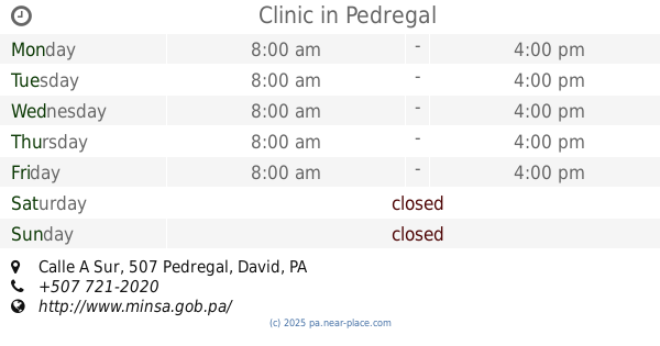
Clinic
Calle A Sur, Pedregal
Hospital
read more
5.923 km
Centro de Salud
Calle A Sur, Pedregal
Hospital
read more
📑
all categories
Accounting
Administrative area level 1
Administrative area level 2
Airport
Amusement park
Aquarium
Art gallery
Atm
Bakery
Bank
Bar
Beauty salon
Bicycle store
Book store
Bowling alley
Bus station
Cafe
Campground
Car dealer
Car rental
Car repair
Car wash
Casino
Cemetery
Church
City hall
Clothing store
Colloquial area
Convenience store
Courthouse
Dentist
Department store
Doctor
Electrician
Electronics store
Embassy
Finance
Fire station
Florist
Food
Funeral home
Furniture store
Gas station
General contractor
Grocery or supermarket
Gym
Hair care
Hardware store
Health
Hindu Temple
Home goods store
Hospital
Insurance agency
Jewelry store
Laundry
Lawyer
Library
Liquor store
Local government office
Locality
Locksmith
Lodging
Meal delivery
Meal takeaway
Mosque
Movie theater
Moving company
Museum
Natural feature
Neighborhood
Night club
Painter
Park
Parking
Pet store
Pharmacy
Physiotherapist
Place of worship
Plumber
Point of interest
Police
Post office
Premise
Real estate agency
Restaurant
Roofing contractor
Route
Rv park, camping
School
Shoe store
Shopping mall
Spa
Stadium
Storage
Store
Subpremise
Subway station
Supermarket
Synagogue
Taxi stand
Train station
Transit station
Travel agency
University
Veterinary care
Zoo
administrative area level 3
sublocality level 1
↑