Restaurant nearby La Brûlerie
Panama
Restaurant nearby La Brûlerie
La Brûlerie
Los Naranjos Panama
contacts phone
:
+507
Latitude:
8.812929
, Longitude:
-82.4833392
read more
nearest Restaurant
2.459 km
Cafetales Urriola
San Ramon, Los Naranjos
Restaurant
read more
4.603 km
Caldera Drive Boquete
Calle 4a Sur, Bajo Boquete
Restaurant
read more
4.672 km
Los Naranjos Restaurant
Vía Boquete, Bajo Boquete
Restaurant
read more
5.174 km
2 Guys & A Cooler
Los Naranjos
Restaurant
read more
5.484 km
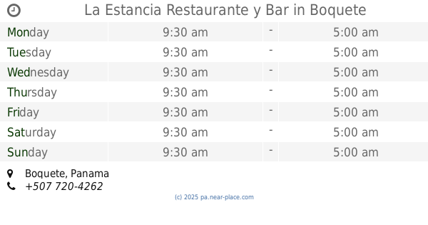
La Estancia Restaurante y Bar
Boquete
Restaurant
read more
5.484 km
La Estancia Restaurante y Bar
Bajo Boquete
Restaurant
read more
5.537 km
Tre Scalini
Calle 4a Sur, Bajo Boquete
Restaurant
read more
5.537 km
Restaurante Riesen
Boquete
Restaurant
read more
5.537 km
Restaurante Riesen
Bajo Boquete
Restaurant
read more
5.804 km
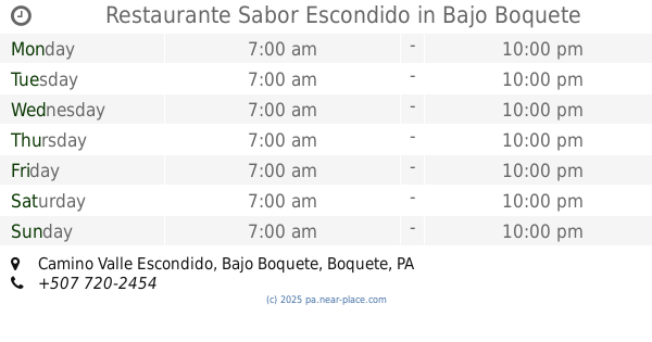
Restaurante Sabor Escondido
Camino Valle Escondido, Bajo Boquete
Restaurant
read more
6.579 km
Restaurante Jeny
Boquete
Restaurant
read more
6.665 km
Mar De Grau Boquete
Bajo Boquete
Restaurant
read more
6.708 km
Butcher Chophouse
Boquete
Restaurant
read more
6.722 km
RetroGusto Restaurant & Bar
Avenida Central, Bajo Boquete
Restaurant
read more
6.811 km
Rosticeria Michell
Avenida Central, Bajo Boquete
Restaurant
read more
6.883 km
Restaurante La Fuente
Avenida Belisario Porras, Bajo Boquete
Restaurant
read more
6.95 km
Big Daddy's Grill
Vía Boquete, Bajo Boquete
Restaurant
read more
7.061 km
JF Restaurant
Boquete
Restaurant
read more
7.334 km
BQT Sport Grill
Boquete
Restaurant
read more
10.703 km
Restaurante Dayra
Cerro Punta
Restaurant
read more
10.734 km
AMIPILA
Cerro Punta
Restaurant
read more
11.21 km
Restaurante Yadira
Unnamed Rd, Cerro Punta
Restaurant
read more
11.835 km
Chop Sticks A Restaurant
Milla 4, Alto Boquete
Restaurant
read more
13.832 km
Cremas Lili,S.A.
Bugaba
Restaurant
read more
14.071 km
Parrilla Argentina
Paso Ancho
Restaurant
read more
📑
all categories
Accounting
Administrative area level 1
Administrative area level 2
Airport
Amusement park
Aquarium
Art gallery
Atm
Bakery
Bank
Bar
Beauty salon
Bicycle store
Book store
Bowling alley
Bus station
Cafe
Campground
Car dealer
Car rental
Car repair
Car wash
Casino
Cemetery
Church
City hall
Clothing store
Colloquial area
Convenience store
Courthouse
Dentist
Department store
Doctor
Electrician
Electronics store
Embassy
Finance
Fire station
Florist
Food
Funeral home
Furniture store
Gas station
General contractor
Grocery or supermarket
Gym
Hair care
Hardware store
Health
Hindu Temple
Home goods store
Hospital
Insurance agency
Jewelry store
Laundry
Lawyer
Library
Liquor store
Local government office
Locality
Locksmith
Lodging
Meal delivery
Meal takeaway
Mosque
Movie theater
Moving company
Museum
Natural feature
Neighborhood
Night club
Painter
Park
Parking
Pet store
Pharmacy
Physiotherapist
Place of worship
Plumber
Point of interest
Police
Post office
Premise
Real estate agency
Restaurant
Roofing contractor
Route
Rv park, camping
School
Shoe store
Shopping mall
Spa
Stadium
Storage
Store
Subpremise
Subway station
Supermarket
Synagogue
Taxi stand
Train station
Transit station
Travel agency
University
Veterinary care
Zoo
administrative area level 3
sublocality level 1
↑