Restaurant nearby Parrillada La Carreta
Panama
Restaurant nearby Parrillada La Carreta
Parrillada La Carreta
Vía España, Panamá Panama
contacts phone
:
+507
Latitude:
9.0175974
, Longitude:
-79.493679
read more
nearest Restaurant
66 m
Vereda Afroantillana DONDE FANSO
avenida y calle, Calle 14 & Av 1B Nte, Panamá
Restaurant
read more
272 m
Fonda Y Lava auto Blizzard
Calle 100 Este, Panamá
Restaurant
read more
321 m
Subway | Parque Lefevre
Calle 4a Parque Lefevre, Panamá
Restaurant
read more
321 m
Subway
Calle 4a Parque Lefevre, Panamá
Restaurant
read more
324 m
Domino's Pizza | Parque Lefevre
Panama City
Restaurant
read more
326 m
Café Guayoyito de Sophie
Parque Lefevre, vía españa, Plaza Lefevre 75, nivel 1, local #39, Panamá
Restaurant
read more
536 m
Barra Brava 507
Avenida Santa Elena, Panamá
Restaurant
read more
665 m
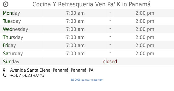
Cocina Y Refresqueria Ven Pa' K
Avenida Santa Elena, Panamá
Restaurant
read more
696 m
Subway |La Gran Estacion
San Miguelito
Restaurant
read more
813 m
Chiqui
Calle W 46B21, Panamá
Restaurant
read more
844 m
Kafu Banton Truck
Calle 19, Panamá
Restaurant
read more
851 m
Popeyes | Río Abajo
Via España, Urb. Parque Lefebre, Panama City
Restaurant
read more
877 m
Popeyes Rio Abajo
Panamá
Restaurant
read more
878 m
Tierra Colombiana
Avenida Cincuentenario, Panamá
Restaurant
read more
880 m
Tierra Colombiana
Panama City
Restaurant
read more
880 m
Tierra Colombiana
Panamá
Restaurant
read more
898 m
Restaurante El Montuno
Vía Cincuentenario, Panamá
Restaurant
read more
935 m
McDonald's
Panamá
Restaurant
read more
962 m
Spring Banquet Hall
Panama City
Restaurant
read more
999 m
Latinos Car Wash Y La Cocina De Titi
Panamá
Restaurant
read more
1.017 km
The Little House
Panama City
Restaurant
read more
1.076 km
Pio Pio | Chanis
Calle 108 Este, Panamá
Restaurant
read more
1.154 km
HFC Cafeteria
Panamá
Restaurant
read more
1.265 km
Big Patacon
Calle 109 Este, Panamá
Restaurant
read more
1.326 km
Fonda Anita
Panamá
Restaurant
read more
📑
all categories
Accounting
Administrative area level 1
Administrative area level 2
Airport
Amusement park
Aquarium
Art gallery
Atm
Bakery
Bank
Bar
Beauty salon
Bicycle store
Book store
Bowling alley
Bus station
Cafe
Campground
Car dealer
Car rental
Car repair
Car wash
Casino
Cemetery
Church
City hall
Clothing store
Colloquial area
Convenience store
Courthouse
Dentist
Department store
Doctor
Electrician
Electronics store
Embassy
Finance
Fire station
Florist
Food
Funeral home
Furniture store
Gas station
General contractor
Grocery or supermarket
Gym
Hair care
Hardware store
Health
Hindu Temple
Home goods store
Hospital
Insurance agency
Jewelry store
Laundry
Lawyer
Library
Liquor store
Local government office
Locality
Locksmith
Lodging
Meal delivery
Meal takeaway
Mosque
Movie theater
Moving company
Museum
Natural feature
Neighborhood
Night club
Painter
Park
Parking
Pet store
Pharmacy
Physiotherapist
Place of worship
Plumber
Point of interest
Police
Post office
Premise
Real estate agency
Restaurant
Roofing contractor
Route
Rv park, camping
School
Shoe store
Shopping mall
Spa
Stadium
Storage
Store
Subpremise
Subway station
Supermarket
Synagogue
Taxi stand
Train station
Transit station
Travel agency
University
Veterinary care
Zoo
administrative area level 3
sublocality level 1
↑