Restaurant nearby Restaurante Bijao
Panama
Restaurant nearby Restaurante Bijao
Restaurante Bijao
San Mateo, David Panamá
contacts phone
:
+507
Latitude:
8.433379
, Longitude:
-82.438809
read more
nearest Restaurant
145 m
Restaurante Donde Yigo
David
Restaurant
read more
255 m
Smokin' Mamma's
Carr. Panamericana, David
Restaurant
read more
409 m
EL PASAJE
Avenida 8a Oeste, David
Restaurant
read more
524 m
Fonda Nitzia
David
Restaurant
read more
543 m
Pizzeria Verona
a lado july sport cente, Carretera Panamericana, David
Restaurant
read more
547 m
GoFresh
Manuel Quintero Villareal, David
Restaurant
read more
564 m
Terraza Sasson
David
Restaurant
read more
566 m
KFC
Avenida 5a Oeste, David
Restaurant
read more
623 m
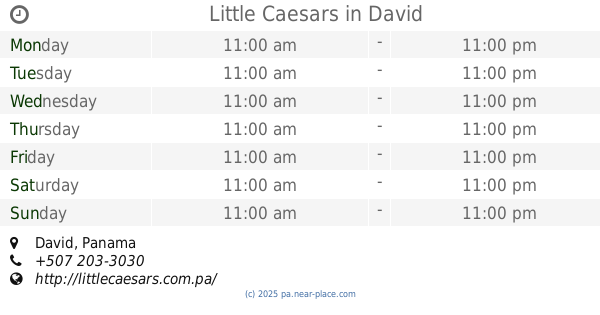
Little Caesars
David
Restaurant
read more
658 m
Restaurante Enelva
Doleguita, David
Restaurant
read more
691 m
La Pikada Sport
Avenida 8a Oeste, David
Restaurant
read more
733 m
A Mi Modo
Avenida 4a Oeste, David
Restaurant
read more
737 m
Crown Casino
David
Restaurant
read more
769 m
Java Juice # 2
Calle E Sur, David
Restaurant
read more
828 m
Restaurante La Negrita # 4
David
Restaurant
read more
853 m
Pizmaricer
Calle Virgencita, David
Restaurant
read more
871 m
Restaurante Donde Julio
Calle D Sur, David
Restaurant
read more
885 m
Restaurante SULTAN
David
Restaurant
read more
888 m
Pio Pio
Calle F Sur, David
Restaurant
read more
953 m
Pollo a La Leña
Calle Miguel A. Brenes, David
Restaurant
read more
1.002 km
Los Ranchos
Calle D Sur, David
Restaurant
read more
1.015 km
Restaurante La Bendición
David, Chiriqui, Calle la Virgencita Diagonal a la Casa del Constructor, Panamá 507, David
Restaurant
read more
1.065 km
Restaurante Vielka
Carretera Panamericana, David
Restaurant
read more
1.09 km
Panama Bill's
David
Restaurant
read more
1.347 km
Rosa Luz
Calle D Sur, David
Restaurant
read more
📑
all categories
Accounting
Administrative area level 1
Administrative area level 2
Airport
Amusement park
Aquarium
Art gallery
Atm
Bakery
Bank
Bar
Beauty salon
Bicycle store
Book store
Bowling alley
Bus station
Cafe
Campground
Car dealer
Car rental
Car repair
Car wash
Casino
Cemetery
Church
City hall
Clothing store
Colloquial area
Convenience store
Courthouse
Dentist
Department store
Doctor
Electrician
Electronics store
Embassy
Finance
Fire station
Florist
Food
Funeral home
Furniture store
Gas station
General contractor
Grocery or supermarket
Gym
Hair care
Hardware store
Health
Hindu Temple
Home goods store
Hospital
Insurance agency
Jewelry store
Laundry
Lawyer
Library
Liquor store
Local government office
Locality
Locksmith
Lodging
Meal delivery
Meal takeaway
Mosque
Movie theater
Moving company
Museum
Natural feature
Neighborhood
Night club
Painter
Park
Parking
Pet store
Pharmacy
Physiotherapist
Place of worship
Plumber
Point of interest
Police
Post office
Premise
Real estate agency
Restaurant
Roofing contractor
Route
Rv park, camping
School
Shoe store
Shopping mall
Spa
Stadium
Storage
Store
Subpremise
Subway station
Supermarket
Synagogue
Taxi stand
Train station
Transit station
Travel agency
University
Veterinary care
Zoo
administrative area level 3
sublocality level 1
↑