School nearby Escuela Kuna Nega
Panama
School nearby Escuela Kuna Nega
Escuela Kuna Nega
Panamá Panamá
contacts phone
:
+507
Latitude:
9.059178
, Longitude:
-79.558975
read more
nearest School
1.142 km
Escuela Villa Cardenas
Panamá
School
read more
2.623 km
Telebasica Santa Librada Rural
Panamá
School
read more
3.909 km
Escuela Nuestra Señora De La Paz
Panamá
School
read more
3.986 km
Royal College of Panama
Panama City
School
read more
4.016 km
Balletto by Carla Garcia
Panama City
School
read more
4.027 km
My Little Genius
Vía Centenario, Panamá
School
read more
4.367 km
Secundaria Del Oxford School
transismica, Transístmica, Panamá
School
read more
4.434 km
Instituto Pedagogico
Las Lajas, Panama City
School
read more
4.51 km
Iglesia de Cristo Metropolitana
Barrio Milla 8.1, Panamá
School
read more
4.6 km
ARCKA LAB
Panama City
School
read more
4.936 km
Vandy Kids Center
Calle 9 A, San Miguelito
School
read more
4.967 km
Escuela Bilingue La Medalla Milagrosa
Linda Vista, Panamá
School
read more
5.349 km
Estacionamientos USMA
Panamá
School
read more
5.401 km
Vicerrectoría de Posgrado, Investigación y Extensión
0819-08550, Calle H
School
read more
5.423 km
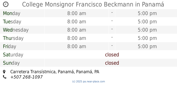
College Monsignor Francisco Beckmann
Carretera Transístmica, Panamá
School
read more
5.423 km
Colegio Monseñor Francisco Beckmann
Carretera Transístmica, Panamá
School
read more
5.453 km
Colegio Bilingue Emanuel Gonzalillo
Panama City
School
read more
5.46 km
Comisariato Leidy
Panamá
School
read more
5.626 km
Kinder Bilingue Amiguitos De Jesus
Panamá
School
read more
5.642 km
Parada Vista linda
Panamá
School
read more
5.694 km
Atter School Program
Panama City
School
read more
6.301 km
Casa De La Misericordia
Panama City
School
read more
6.409 km
Escuela Republica de Rumania
Panamá
School
read more
6.49 km
ISBAD
Panama City
School
read more
6.531 km
Chikiteam
Club X, Panamá
School
read more
📑
all categories
Accounting
Administrative area level 1
Administrative area level 2
Airport
Amusement park
Aquarium
Art gallery
Atm
Bakery
Bank
Bar
Beauty salon
Bicycle store
Book store
Bowling alley
Bus station
Cafe
Campground
Car dealer
Car rental
Car repair
Car wash
Casino
Cemetery
Church
City hall
Clothing store
Colloquial area
Convenience store
Courthouse
Dentist
Department store
Doctor
Electrician
Electronics store
Embassy
Finance
Fire station
Florist
Food
Funeral home
Furniture store
Gas station
General contractor
Grocery or supermarket
Gym
Hair care
Hardware store
Health
Hindu Temple
Home goods store
Hospital
Insurance agency
Jewelry store
Laundry
Lawyer
Library
Liquor store
Local government office
Locality
Locksmith
Lodging
Meal delivery
Meal takeaway
Mosque
Movie theater
Moving company
Museum
Natural feature
Neighborhood
Night club
Painter
Park
Parking
Pet store
Pharmacy
Physiotherapist
Place of worship
Plumber
Point of interest
Police
Post office
Premise
Real estate agency
Restaurant
Roofing contractor
Route
Rv park, camping
School
Shoe store
Shopping mall
Spa
Stadium
Storage
Store
Subpremise
Subway station
Supermarket
Synagogue
Taxi stand
Train station
Transit station
Travel agency
University
Veterinary care
Zoo
administrative area level 3
sublocality level 1
↑