Supermarket nearby Mini Super El Paso
Panama
Supermarket nearby Mini Super El Paso
Mini Super El Paso
El Coco, Panama
contacts phone
:
+507
Latitude:
8.8684507
, Longitude:
-79.8166371
larger map & directions
read more
nearest Supermarket
328 m
mini super yissileidi #2
La Chorrera
Supermarket
read more
505 m
Bello Horizonte El Coco
El Coco
Supermarket
read more
1.019 km
Mini Super Hc
La Chorrera
Supermarket
read more
1.138 km
Mini Super Bazan
La Chorrera
Supermarket
read more
1.184 km
Mini Super Jose Y Susana
La Chorrera
Supermarket
read more
1.25 km
Minisuper Bianchery
La Chorrera
Supermarket
read more
1.382 km
Minisuper La Sirena
El Coco
Supermarket
read more
1.445 km
Mini Super Carmen
8°51'27.9"N 79°49'26.7"W, Calle 53 Este, Panamá
Supermarket
read more
1.445 km
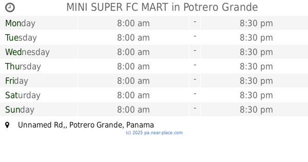
MINI SUPER FC MART
Unnamed Rd,, Potrero Grande
Supermarket
read more
1.445 km
Carmen Mini Market
8°51'27.9"N 79°49'26.7"W, Calle 53 Este, Panamá
Supermarket
read more
1.56 km
Mini Super Lily
La Chorrera
Supermarket
read more
1.648 km
Mini Super Suset
La Chorrera
Supermarket
read more
1.728 km
Supermercado Guadalupe
La Chorrera
Supermarket
read more
1.774 km
Supermercado Xtra
La Chorrera
Supermarket
read more
1.862 km
Mini Super Dorian
La Chorrera
Supermarket
read more
1.891 km
Comisariato
La Chorrera
Supermarket
read more
1.934 km
Supermercado Elena
La Chorrera
Supermarket
read more
1.99 km
Super Market House Ibeth
Calle La Pesa, La Chorrera
Supermarket
read more
2.021 km
Mini Super Yoselin
La Chorrera
Supermarket
read more
2.292 km
Mini Super Lucky
La Chorrera
Supermarket
read more
2.325 km
Minisuper Kavit
La Chorrera
Supermarket
read more
2.435 km
Supermarket Villa Del Carmen
La Chorrera
Supermarket
read more
2.435 km
Supermercado Villa Del Carmen
La Chorrera
Supermarket
read more
2.58 km
Mini Super Oriente
San Vernaldino, La Chorrera
Supermarket
read more
2.673 km
MiniSuper La Tulihueca
La Chorrera
Supermarket
read more
📑
all categories
Accounting
Administrative area level 1
Administrative area level 2
Airport
Amusement park
Aquarium
Art gallery
Atm
Bakery
Bank
Bar
Beauty salon
Bicycle store
Book store
Bowling alley
Bus station
Cafe
Campground
Car dealer
Car rental
Car repair
Car wash
Casino
Cemetery
Church
City hall
Clothing store
Colloquial area
Convenience store
Courthouse
Dentist
Department store
Doctor
Electrician
Electronics store
Embassy
Finance
Fire station
Florist
Food
Funeral home
Furniture store
Gas station
General contractor
Grocery or supermarket
Gym
Hair care
Hardware store
Health
Hindu Temple
Home goods store
Hospital
Insurance agency
Jewelry store
Laundry
Lawyer
Library
Liquor store
Local government office
Locality
Locksmith
Lodging
Meal delivery
Meal takeaway
Mosque
Movie theater
Moving company
Museum
Natural feature
Neighborhood
Night club
Painter
Park
Parking
Pet store
Pharmacy
Physiotherapist
Place of worship
Plumber
Point of interest
Police
Post office
Premise
Real estate agency
Restaurant
Roofing contractor
Route
Rv park, camping
School
Shoe store
Shopping mall
Spa
Stadium
Storage
Store
Subpremise
Subway station
Supermarket
Synagogue
Taxi stand
Train station
Transit station
Travel agency
University
Veterinary care
Zoo
administrative area level 3
sublocality level 1
↑